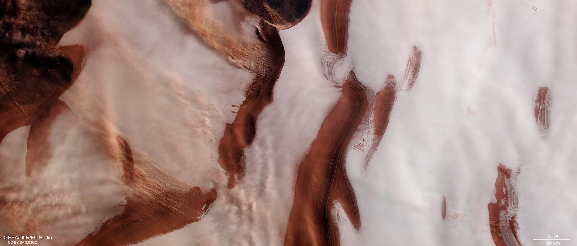
The European Space Agency has released this striking image of the northern pole of Mars, showing stormy weather raging over ripples of dust and ice.
The image was captured at the north polar ice cap, which is covered in water ice year-round. In the freezing winter months, when the temperature on the surface drops as low as -125 degrees Celsius (-193 degrees Fahrenheit), the water ice is further covered by several meters of carbon dioxide ice. But in this image, it is summertime, when it is easier to image the poles as there are fewer clouds of carbon dioxide to obscure the view.
The ripples of brown between the streaks of white ice are Martian dust, which when viewed from a sufficient distance reveal a pattern of troughs which “curve and bend and slice outwards in an anti-clockwise orientation, wrapping around the pole and creating a pattern akin to zebra stripes,” according to the ESA. This elaborate pattern is thought to be caused by wind erosion, as winds circle the pole and spread out radially carrying cold, dry air with them.
Along with the ice and dust, you can also see streams of clouds on the left of the image, flowing across the troughs. These clouds are formed by small storms which move around the dust and shape the troughs over time like river-shaped rocks.
Scientists are interested in studying the layers of ice in the polar regions in order to learn more about the history of the Martian climate. As dust settles on the ice and the two are mixed together, the layers form a snapshot of the climate over time.
The image was taken with an instrument called the High Resolution Stereo Camera (HRSC) aboard the Mars Express orbiter. The HRSC can image the entire planet in color and in 3D, with a resolution of around 10 meters. It is particularly useful for capturing terrain data to see the topography of the surface.
Previous data captured by Mars Express include an image of an icy crater more than 50 miles wide, clues about the history of water on Mars, and a beautiful pole-to-pole image of the entire planet.
Editors' Recommendations
- See ridged ‘brain terrain’ crater captured by Mars Express
- Otherworldly Mars image shows ripples sculpted by dust devils
- See a gorgeous icy crater on Mars captured by the Trace Gas Orbiter
- Trace Gas Orbiter finds a canyon on Mars ‘packed full’ of water ice
- See Ingenuity hovering over the surface of Mars as captured by Perseverance