
Old NASA satellite predicted to reenter the atmosphere tomorrow

An old NASA satellite is set to reenter the atmosphere tomorrow, Sunday, January 8. Though most of the satellite is expected to burn up in the atmosphere and pose minimal risk, some debris could reach the surface. NASA satellites launched today are designed to deorbit more gracefully and with less risk of creating space debris, but this satellite was launched in 1984 before guidelines were in place.

The current guidelines, updated in November 2019, require that any risk of a deorbiting satellite impacting people on Earth is less than 1 in 10,000. The old satellite doesn’t quite meet that requirement as there is marginally more risk from its impact. “NASA expects most of the satellite to burn up as it travels through the atmosphere, but some components are expected to survive the reentry,” the agency wrote in a statement. “The risk of harm coming to anyone on Earth is very low – approximately 1 in 9,400.”

NASA’s retired Earth Radiation Budget Satellite (ERBS) is expected to reenter Earth’s atmosphere in early January.
NASA’s retired Earth Radiation Budget Satellite (ERBS) is expected to reenter Earth’s atmosphere in early January. NASA

The Department of Defense predicts that the satellite will reenter the atmosphere within a 17-hour window on either side of 6:40 p.m. ET on Sunday. Tracking of the satellite will continue, as it is not yet known where any debris could be expected to land.

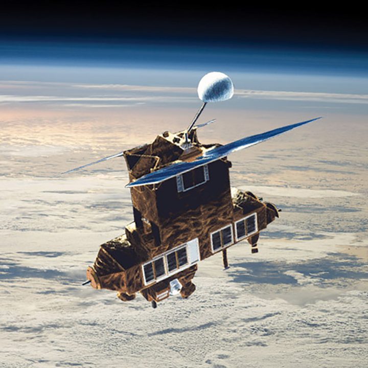
The satellite is called Earth Radiation Budget Satellite or ERBS and weighs 5,400 pounds. Launched in 1984, it was an early tool for investigating climate change from space. Among other things, it measured the Earth’s radiative energy budget, which refers to how much energy our planet gets from the sun and how much it emits out into space. This measurement is related to climate factors such as aerosols and greenhouse gases as well as formations such as clouds and surface geography.

Running far beyond its originally planned lifespan of two years, ERBS continued to collect data until 2005 — making it a 21-year mission in total. The satellite was launched from the Space Shuttle Challenger and is notable for having trouble with deploying its solar panels when first launched. Pioneering American astronaut Sally Ride had to use a robotic arm from the Space Shuttle to shake it loose and move the panel into sunlight, allowing it to fully deploy.

Editors' Recommendations

Georgina Torbet
Georgina is the Digital Trends space writer, covering human space exploration, planetary science, and cosmology. She…
NASA’s amazing Mars helicopter just set a new flight record
The shadow of the Ingenuity helicopter during a flight on Mars.

NASA’s Mars helicopter, Ingenuity, has set a new flight record on the red planet.

On its 59th flight just a few days ago, the drone-like machine reached an altitude of 20 meters, beating its previous record, set in December last year, by 6 meters.

Read more
Here’s where NASA will land astronauts on the moon
Shrouded in permanent darkness, the interior of Shackleton crater near the moon’s south pole is revealed in this stunning mosaic. The crater itself was captured by ShadowCam, a NASA instrument designed to peer into the shadowy parts of the lunar surface that has been orbiting the moon for almost a year on the South Korean spacecraft Danuri. The surrounding areas were imaged by the Lunar Reconnaissance Orbiter Camera. Portions of three of the 13 potential landing regions for astronauts during Artemis III can be seen in this image.

A new image of the moon's far side shows the region selected for the landing of NASA's Artemis III mission, which aims to return humans to the lunar surface for the first time in over 50 years. The mission will be to the moon's south pole, a region of particular scientific interest because it is thought to host water ice in permanently shadowed craters.

NASA has partnered with National Geographic to release a mosaic image of the Shackleton Crater, located at the moon's south pole. The image of the crater was captured using NASA's ShadowCam instrument on the Korea Pathfinder Lunar Orbiter spacecraft, with additional images of the surrounding area coming from the Lunar Reconnaissance Orbiter. It's one of the permanently shadowed craters in the region, meaning it could potentially hold water ice. The crater is also close to several of the potential landing sites.

Read more
How to watch final moments of NASA’s first asteroid sample return mission
This mosaic of Bennu was created using observations made by NASA’s OSIRIS-REx spacecraft that was in close proximity to the asteroid for over two years.

OSIRIS-REx: 1st US Asteroid Sample Lands Soon (Official NASA Trailer)

In just a few days from now, NASA will oversee the final moments of its groundbreaking OSIRIS-REx mission, which marks the first time for the agency to bring back rock samples collected from a distant asteroid.

Read more