
Brick Street View turns Google Maps into Lego

brick street view turns google maps into lego new york
Image used with permission by copyright holder
Swedish coder Einar Öberg has hacked an impressive layer on top of Google Street View inspired by Lego building blocks. Open up Brick Street View in your browser and you can tour around any part of the world as if it was constructed in Lego, complete with toy cars and trees. It’s perfect if you’ve always wanted to see your city in Lego form but just never had the blocks or the time to do it yourself.

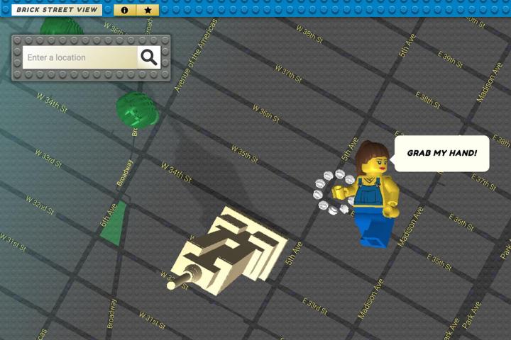
The software Öberg has put together creates a pixelated mosaic of blocks based on the colors of Google’s imagery — it doesn’t work perfectly, but it’s a cool bit of coding nevertheless. The addition of a Lego sky backdrop, complete with Lego sun, is a nice touch too. To see a location you simply drop your Lego character onto a street, just as you do in the original Google Street View.

If you’re interested in the software that powers Brick Street View, Öberg has provided an About page with a little bit more information. LDraw, BRIGL, GSVPano, GSVPanoDepth, ThreeJS, Google Places API, and Google App Engine are some of the technologies involved. The finished result depends on the quality of the depth data provided by Google, Öberg says.

It’s a fun way of spending a few minutes of your weekend, if nothing else. Also worth a look is an earlier project by Einar Öberg called Urban Jungle Street View — in this case the data pulled from Google’s database is covered with foliage, as if you’ve just stepped into a post-apocalyptic world abandoned by humanity. It has an eerie, The Last of Us-type feel about it, and it’s another impressive showcase for Öberg’s programming talents.

Editors' Recommendations

David Nield
Dave is a freelance journalist from Manchester in the north-west of England. He's been writing about technology since the…
See how Google Maps is using color to add even more detail
see how google maps is using color to add even more detail iceland update

Google Maps is getting even better with the greater use of color to depict additional geographical details in natural features.

Google Maps product manager Sujoy Banerjee said the visual improvement will bring “even more detail and granularity to the map, making it easier to understand what an area looks like whether you’re exploring virtually or planning a visit.”

Read more
Google Maps reminds you to wear a mask in new update
man checking phone with mask on

If you’re looking for a restaurant or coffee shop to go to, Google Maps now reminds you to wear your mask before leaving your house.

A new banner that says, “Wear a Mask. Save Lives.” now appears on your Maps’ “Explore” tab if you're using an Android phone. 

Read more
Google Maps, Bing Maps add marker for Black Lives Matter Plaza in Washington D.C.
Google Maps Adds Marker for Black Lives Plaza

Google Maps and Bing Maps have added a marker for the "Black Lives Matter Plaza" in Washington D.C., after a section of the street directly in front of the White House was officially renamed by the city's mayor and painted with the protest slogan.

Social unrest has swept through the U.S. over the past couple of weeks, triggered by the killing of George Floyd in Minneapolis by city police officers. Washington, D.C., has seen its own protests with thousands in attendance.

Read more