
Citymaps brings its personalized, place-based maps to the whole world

It happens all the time — You’re walking around in the city where you’ve lived for five years and you just can’t remember if your favorite pizza place was on 17th or 18th Street. You know it’s between 5th and 6th Ave, but you just never remember the street number. Google Maps will help you, if you know the name of the place, but what if you don’t? Hey, some of us are chronically forgetful.

“One good review from your friends is worth 100 reviews from strangers.”

That’s where Citymaps comes in. It’s a personalized map that’s based on places — not streets, rivers, or mountains — and they’re not just any places. There’re ones you know and love. As you pinch and zoom around the map, you find all your favorite places and you save them. Once you’ve done that, you’ll never forget a place. The more places you add, the more personal your map becomes.

Citymaps founder and CEO Elliot Cohen describes the app as a “personalized map for places,” adding that “Citymaps focuses on places as much as roads and rivers.” Choen believes that there are enough map apps out there that focus on directions, but not enough that are made for local discovery, so “we focus on places and build a map with that as an entry point.”

You can also follow people, celebrities, friends, and publications whose opinions you respect to find new places. Since most places have reviews and user pictures, it’s easy to see whether it’s somewhere you want to go. Citymaps lets you make as many lists and special maps as you want, so you can plan a trip with a friend, or simply plot out your next weekend. Each place is marked with the company’s logo, so they’re easy to identify and find on the map.

IMG_6120
Malarie Gokey/Digital Trends

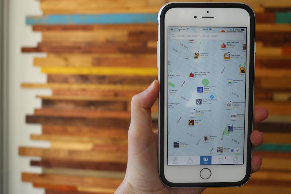
“We think that a logo is a more natural way to specify a place than a red dot or a pin,” Cohen told us, adding that,”We get a ton of user-generated content from business owners who want to be represented on the map … They even get upset sometimes when they’re not on the map.”

Now that the company’s expanded globally, it has information for 80 million places around the world. Every place comes with basic info like directions to the place, the phone number, hours, website, star ratings, and more.

“We’ve been working for the last year and a half for global launch,” he said. “We’ve been working furiously to expand.”

The more places you add, the more personal your map becomes.

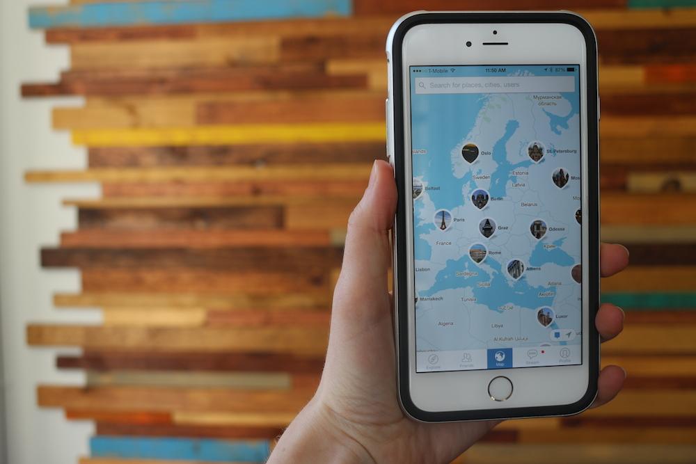
Now, Citymaps is ready. The app offers the same level of detail it has for its hometown, New York, in a plethora of cities and towns around the entire world. Want to see what’s happening in Barcelona, Paris, Hong Kong, or San Francisco? Just zoom out and spin the globe to where you want to go, and you’re there.

If you’ve already added a bunch of places to your map before, Citymaps will recommend places that you might like, based on your earlier searches and maps. Some locations even show you coupons, deals, and events that are happening. For example, if you zoom in on the Metropolitan Museum of Art in New York, you’ll see what’s currently in the exhibition halls.

IMG_6123
Malarie Gokey/Digital Trends

“We want to remove the steps involved in finding a place, mapping it out, and seeing what your friends think about it,” Cohen said.

Since anyone you follow can see your Citymaps, it’s easy to collaborate with friends to plan trips, or a simple night out on the town. Additionally, you’ll see all the places your friends liked as recommendations, seeing as like-minded people are typically friends, Cohen explained.

“One good review from your friends is worth 100 reviews from strangers,” he said.

Now that Citymaps is available in most places around the world, Cohen’s plans center around adding more places, improving personalization, and adding more social elements to the app, such as messaging and more collaborative map sharing. In the meantime, you can check out Citymaps on the iOS App Store or Google Play Store.

Malarie Gokey
Former Digital Trends Contributor
As DT's Mobile Editor, Malarie runs the Mobile and Wearables sections, which cover smartphones, tablets, smartwatches, and…
Google’s Android monopoly finds its biggest challenge, and Apple might be next
Apps screen on the Google Pixel 7.

The Competition Commission of India slapped Google with two hefty fines over anti-competitive strategies that have allowed it to dominate the mobile ecosystem in India. Totaling over $250 million, the penalties reprimand Google for forcing smartphone makers to avoid Android forks, prefer Google’s web search service, and pre-install popular cash cows like YouTube on phones.

Google was also disciplined for forcing its own billing system on developers that allowed the giant to take up to a 30% share of all in-app purchases for applications listed on the app store. Google is not really a stranger to titanic penalties; The EU handed Google a record-breaking fine of approximately $5 billion in 2018 for abusing its dominant market position — a penalty that was upheld in September this year following Google’s appeal.

Read more
Apple Maps enhances road trips with multistop routing, transit fares
Apple Maps running on an iPhone and MacBook Pro.

Amid a barrage of updates to iOS 16's lock screen, Apple Pay, and more, Apple also used its WWDC 2022 keynote to unveil several changes to Apple Maps. While Apple Maps has long been the butt of many jokes, Apple's mapping application is poised to get a few key features this year, including multistop routing, new transit information, and more detailed maps in more cities and countries.
Multistop routing
Multistop routing is the highlight of this year's Maps update, and it's bound to be the most useful for folks. With this update, Maps users can create a route with up to 15 stops on the way to their final destination. Planning a big road trip and want to schedule a few stops at gas stations or restaurants along the way? Multistop routing lets you do that. You can create multistop routes directly on your iPhone or on your Mac and send them to your iPhone when you're ready to hit the road.

New transit features
Another standout feature is how Apple Maps is improving transit information. While traveling or planning your route, Apple Maps will show you any upcoming fares and how much they'll cost — ensuring there are no surprise costs along the way. But Apple Maps doesn't stop there. If you have a transit card saved in Apple Pay (which was also just updated at WWDC 2022), Apple Maps will show its remaining balance and alert you if it needs additional funds.
Better maps for more users
Beyond those functional changes, Apple Maps is also getting a few significant visual improvements. Developers can use the MapKit API to integrate enhanced visuals in select cities. This includes high-resolution renders for homes on Zillow, and Bird making its bikes and scooters more easily visible.

Read more
Apple Maps brings major update to Canadian cities
An iPhone 13 in the hands of a user.

Apple Maps ushered in new, detailed 3D city maps with the release of iOS 15 and now Canada's biggest cities have been added to the feature. Apple device users are able to view Montreal, Toronto, and Vancouver in more detail than ever before using Apple Maps, according to an announcement made by Apple. The update provides much more precise environmental information as the app shows individual buildings and landmarks, giving users the ability to truly make sense of their surroundings.

When the feature debuted in a handful of American and English cities, users were impressed with the level of detail in each map. But the number of cities available was a little disappointing to anyone outside of the U.S. and London, so bringing detailed 3D maps to another country is an exciting development for the tech.

Read more