

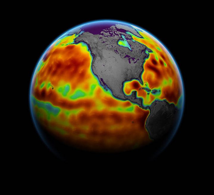
Climate change is an imminent threat to humanity’s future, but the global climate is so complex that it’s often hard to even see the scale of the problem. One of the best ways we have to measure climate change might not be what you expect – because it’s not about measuring the land or the atmosphere. Instead, to learn about climate change, we need to measure the ocean.
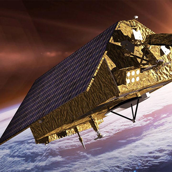
The rising of sea levels not only affects coastal communities by reducing land mass, but also indicates the wider issue of rising global temperatures. That means sea level rise is of great importance to NASA, which doesn’t just look out to other worlds, but also monitors the Earth from space. A new sea-level monitoring satellite, Sentinel-6 Michael Freilich, was launched in November 2020 and became the official reference mission for sea level rise in March this year, after taking over from its predecessor, Jason-3.
With Sentinel-6 taking on its new role, and a twin successor, Sentinel-6b, waiting in the wings to take up the baton when required, we’re set for the next 10 years of sea level measurements. You can even see for yourself where Sentinel-6 is located over the Earth right now, by tracking it using NASA’s Eyes web application.
We spoke to Josh Willis of NASA’s Jet Propulsion Laboratory, project scientist for both Sentinel-6 and Jason-3, about how to measure sea level rise from space.
Our scorecard for climate change
Sea level rise isn’t only important to understand the changing oceans. It’s also one of the most valuable tools we have for measuring climate change as a whole. “In a way, it’s a scorecard,” Willis said. “It’s our scorecard for how we’re doing with the climate.”
That’s because much of the rising average temperature of the planet as a whole is reflected by the level of the oceans. There are three big human-caused factors contributing to sea level rise: The melting of the ice sheets in Greenland and Antarctica, the melting of small glaciers elsewhere around the globe, and the warming of the ocean that’scausing it to expand. These factors contribute roughly one third each to the total rise, due to more water being added to the oceans when glaciers and ice caps melt, as well as the expansion of the water due to increasing global temperatures. As the oceans cover so much of the globe, they end up absorbing a lot of the excess heat generated by human activity.
“I think of sea level rise as the clearest indicator of human interference with the climate,” Willis said. “Oceans cover two-thirds of the surface of the planet, they absorb 90% of this extra heat that’s the whole cause of climate change, and they’re also absorbing all the water that’s melting from the glaciers and ice sheets. So they’re really counting everything in terms of how we’re changing the climate in the most big-picture way.”
And the problem is not only that sea levels are rising. It’s that the rate of that rise is going up as well.
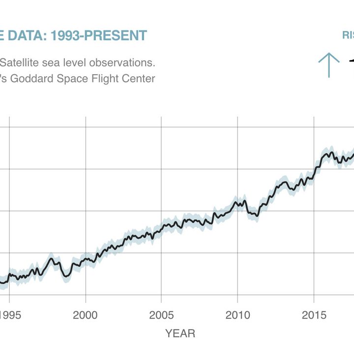
“The rate of rise of the oceans isn’t steady. It’s actually increasing,” Willis said. “In the early part of the 20th century, oceans were rising at a rate of around two millimeters per year. By the 90s or 2000s, it was more like three. And now it’s been four and five millimeters per year. So the rate of rise has more than doubled in the last hundred years. And it’s going to continue to increase faster and faster.”
30 years of continuous measurements
Part of the reason sea level rise data is so valuable is that it forms a long-term record that has been collected since the 1990s. The first global measurements of the oceans from space began when the TOPEX/Poseidon mission was launched in 1992, followed by the three Jason satellites, and then the first Sentinel.
To keep consistent data that can be compared across the years, all of the missions in this series have been placed into the same orbit so that they get the same view of the oceans.
Whenever a new satellite took over from its predecessor, the two would fly close together for months. This allowed very careful calibration to ensure that data could be traced consistently across the five satellites to date.
“It’s really an amazing accomplishment in terms of our climate science record,” Willis said.
Another 10 years of measurements
“We have this incredible record that’s 30 years long now, and Sentinel-6 was built to extend that record by 10 more years,” Willis said. To enable this extra 10 years of observations, NASA built not one but two satellites, both essentially identical, so that once the recently launched Sentinel-6 Michael Freilich comes to the end of its life in 2025, its twin Sentinel-6b can take over. That will enable a total of 40 years of consistent records of sea level rise.
“It’s the first time we’ve decided as a community to do this for the long term – to commit to doing sea level rise measurements from space, not just one satellite at a time,” he said. “Sea levels aren’t going to stop rising any time soon, we’re not going to be able to quit measuring it, so we need to have this continuity of measurements across missions.”
If it seems like these satellites have a relatively short life expectancy when compared to other satellite missions that might last decades, that’s related to the altitude at which they operate. When the first sea level rise satellites were launched, we didn’t have such good technology for determining the position of those satellites – and positioning data is important to get accurate sea level readings. To allow for this, the satellites were launched into a very high orbit of 1,300 kilometers, where there is very little atmosphere and therefore very little protection from radiation.
Researchers want to keep sending satellites to this same orbit to ensure continuous measurements, but that means accepting that these satellites will be battered by radiation and will only last a relatively few years each.
Instruments on the satellite
The accuracy of its readings is what allows the Sentinel-6 satellite to be the internationally recognized tool for measuring sea level rise. Researchers from all different fields and different countries have agreed that the measurements taken from Sentinel-6 and its predecessors would be used as the standard measurement for sea level rise.
The instruments on Sentinel-6 are relatively simple, conceptually at least. There’s the radar, which sends radio waves down to the surface to measure the distance between the satellite and the ocean, the positioning systems that give information about the satellite’s altitude so this can be subtracted from the sea level measurements, and then one more important instrument called a radiometer.
The radiometer measures the amount of water in the atmosphere by looking at the brightness of the ocean. The water in the atmosphere affects the radio waves sent by the radar, so the radiometer is required to correct for this and ensure a high level of accuracy for sea level measurements.
These three instruments, along with the consistent orbits, are what makes Sentinel-6 the most accurate method we have for measuring sea level rise – and that’s why it is accurate enough to be the international reference mission.
The changing oceans
The more complicated part of measuring sea level rise is how to interpret the data collected by the satellite. The oceans aren’t flat, so the satellite averages out readings over an area of several square kilometers to allow for this.
But there are other factors that affect sea levels as well. This includes the weather as changes in atmospheric pressure allow the sea to dome up when pressure is low, the tides and ocean currents, and even the gravity of underwater mountains, which cause peaks to appear in the sea level above them. The researchers using data from Sentinel-6 to measure sea level rise have to account for these other factors by considering data on atmospheric conditions and maps of the gravity field of the ocean.
All of these other effects can give useful data for other fields of research though. By looking at how much a reading has been averaged over a given area, researchers can estimate how big the waves are, and how strong the winds are. They can see how currents are moving through the ocean in real time, because currents cause the ocean to tilt so one side of the current is higher than the other. They can also track debris or oil when it is spilled in the ocean.
The satellite also keeps collecting data when passing over land and this data can be used to monitor lakes and rivers.
All of the data collected by the satellite is publicly available, and it is used by researchers all over the world from a wide variety of fields. You can find the data on the JPL website or on NASA’s Earth data website.
The threat of climate change
With projects like Sentinel-6, we can directly see the way our climate is changing due to our activities as humans. We can see that not only are sea levels rising, but that they are rising faster and faster, and there’s no indication this change will slow down or stop any time soon. There’s an existential terror to that.
“As we watch what’s happening to the planet, it is scary,” Willis said. “We’ve already driven our climate into unfamiliar territory. And it’s getting more and more unfamiliar every year.”
However, he doesn’t despair at humanity’s future. Rather, he emphasizes that the future of our planet is in our own hands.
“There is still room for hope, because this is something we can do something about,” Willis said. “We know what the problem is, and we know pretty much how to fix it. It’s not like there’s a giant meteor that’s heading for the Earth that’s going to wipe us all out. We actually can do something about climate change, we just have to summon the will.”


